Forecasters: Tropical Storm Sandy Not Expected to Significantly Impact Keys
The potential for an expanding wind field from Tropical Storm Sandy has prompted forecasters at the National Hurricane Center to issue a precautionary tropical storm watch for the southeast portion of Florida from Craig Key near Islamorada northward to Jupiter. This includes Key Largo, Flamingo and Florida Bay. Tropical storm conditions, with winds in excess of 39 mph, are possible within 48 hours.
There are no watches or warnings in effect for other parts of the Keys including Marathon, Big Pine and the Lower Keys and Key West.
The Florida Keys and the remainder of Florida, are currently out of the hurricane center's official forecast error track cone.
Although the storm's track is not expected to change appreciably, the wind field is projected to expand and there is a possibility of minimal to moderate tropical-storm force winds brushing the southeast Florida coast and the Upper Keys.
A small craft advisory is also in effect for the waters throughout the entire Keys. A small craft advisory means that wind speeds of 25 to 35 mph and/or seas seven feet or higher are expected to produce hazardous conditions for boats. Boaters, especially those with smaller vessels, should avoid operating in these conditions.
Elsewhere in the tropics, newly formed Tropical Storm Tony is some 2,000 mile east of Florida and poses no threat to North America.
Online:
National Hurricane Center
Key West National Weather Service
Oct. 23, 2012 • 11 p.m.
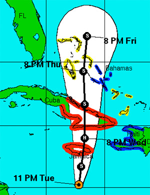
The official forecast track for Tropical Storm Sandy, as issued by the National Hurricane Center, released Tuesday at 11 p.m. NHC Graphic.